


In northwestern China’s Xinjiang Uygur Autonomous Region, and some 2,500 kilometers directly northwest of Beijing, stands the center of the Eurasian continent and the most distant point on the Earth’s surface from any coastline.
Apart from its central location in the far-flung recesses of the continental interior, the region is also as expansive as it is remote. Xinjiang is the largest provincial-level administrative region in China at 1.66 million square kilometers, taking up a sixth of the country’s total territory. As a frontier region in China’s western hinterlands, Xinjiang shares a common border with eight countries, a national borderline that runs more than 5,600 kilometers in length, or about one quarter of China’s total land boundary.
Moreover, the vast landscape of Xinjiang is similarly defined by its many geographical and climatic contrasts. At 155 meters below sea level, the Turfan Depression at the eastern edge of the Tianshan Mountains (‘Celestial Mountains’) is among the lowest places on Earth and is known as China’s Death Valley with summertime temperatures reaching as high as 49 degrees Celsius and ground temperatures exceeding 80 degrees Celsius. Some 600 kilometers due north, in the Altay Mountains along the far tip of northern Xinjiang, the region’s lowest temperature was recorded at just under minus 52 degrees Celsius in Fuyun County, which sits at an average altitude of between 800 to 1,200 meters above sea level, rising to beyond 3,800 meters at its highest elevation.
The rugged Karakoram, Pamir, Kunlun and Altun mountain chains form natural barriers along the southwestern and southern border regions of Xinjiang, with the Qinghai-Tibetan Plateau blocking immediate access to the Indian subcontinent. Reaching towards the heavens with peaks soaring over 7,000 meters, the snow-capped Tianshan mountain range that stretches 2,500 kilometers east-west across Central Asia into China and Mongolia also generates a natural north-south dividing line for the landlocked territory.
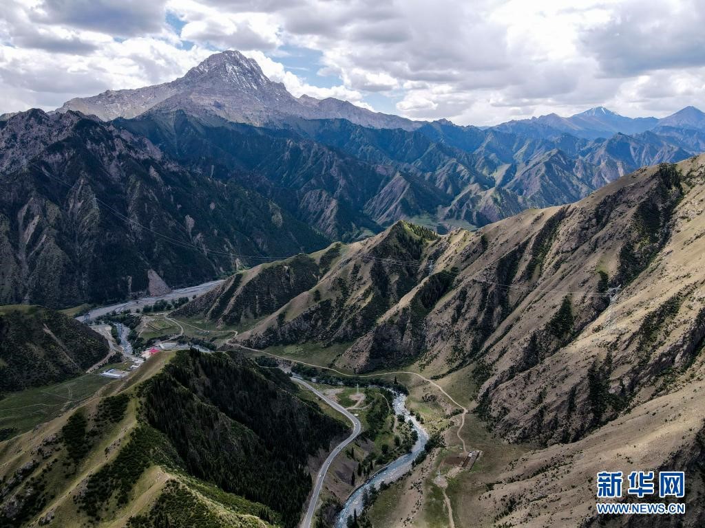
Aerial photo taken of a section of the 560-kilometer-long Duku Highway, a scenic roadway cutting through the snow-capped peaks, forests and river valleys of the Tianshan mountain range, connecting up the northern and southern sub-regions of northwest China’s Xinjiang Uygur Autonomous Region. (Xinhua /Gao Han)
Northern Xinjiang hosts the capital of the autonomous region, Urumqi, and is characterized by vast steppe grasslands and montane terrain, its cooler and wetter climate at variance with southern Xinjiang whose central expanse is defined by the Tarim Basin, a massive inland drainage depression in China’s northwest. The basin is dominated by the Taklimakan Desert, the world’s second largest shifting-sand desert at 337,000 square kilometers, the desolate sun-scorched landscape having earned the harrowing monikers “Sea of Death” within the popular imagination; while in the local Uyghur language, the placename for the rolling crescent-shaped dunes of sand translates with equal foreboding: “Once you enter, you’ll never come out.”
Average temperatures across the arid and water scarce continental basin can range drastically, with the lowest temperatures in the winter dropping down to freezing subzero temperatures below minus 20 degrees Celsius, while in the hot summer months the maximum can pierce the 40 degrees Celsius mark.
Inhospitable and devoid of vegetation, and with annual precipitation of well below 100 millimeters, rivers and springs formed from glacial deposits and melting snow on high undulate down alluvial fans below into the low-lying basin of southern Xinjiang, including the 144 drainage systems and 9 tributaries that historically converged into its namesake Tarim River , these water flows having fed the isolated yet fertile oases that have dotted the outer rim of the Taklimakan Desert since time immemorial.
For thousands of years, merchants and traders have occupied these lands at the crossroads of civilizations, taking refuge in the bustling trading posts that sprung up around the desert oases. The main routes for the ancient Silk Road, which served as a major catalyst for early globalization across the whole of Eurasia, also reflected the natural conditions of the physical environment that confronted caravans traversing the well-worn trade routes. Setting off from Chang’an (modern-day Xi’an) in the Central Plains of China and passing through the narrow Hexi Corridor (the main artery on the ancient Silk Road) on the western edge of the Yellow River towards Dunhuang, the Silk Road split into two in Xinjiang running north and south of the Tianshan Mountains, with the southerly routes meeting up at Kashgar, a critical nexus between the ancient eastern and western Silk Roads.
Bolts of fine silk fabrics, bronzes, porcelain and lacquer-ware were carried off to Europe, Western and Central Asia, while sturdy horses, wool, spices, grapes, figs and pomegranate, among other valuable goods, were introduced to the Chinese empire, these material flows having likewise promoted the interchange of peoples, religions, languages and cultural traditions as well as technological and scientific know-how, such as ancient texts, agricultural techniques, gunpowder, glass- and paper-making, all of which spread to regions far and wide.
While the ancient Silk Road served as a bridge for commercial and cultural interchange between distant settlements and seemingly disparate peoples, these were meanwhile the same routes travelled by intrepid explorers and missionaries, as most notably recorded in the travelogues of Marco Polo and Ibn Battuta in their respective expeditions from the confines of the Mediterranean Sea to the Middle Kingdom in the Far East during the 13th and 14th centuries, and from accounts of the Chinese admiral Zheng He on his seven voyages in the early 15th century to bolster diplomatic and cultural contact and tributary trade in lands surrounding the Indian Ocean.
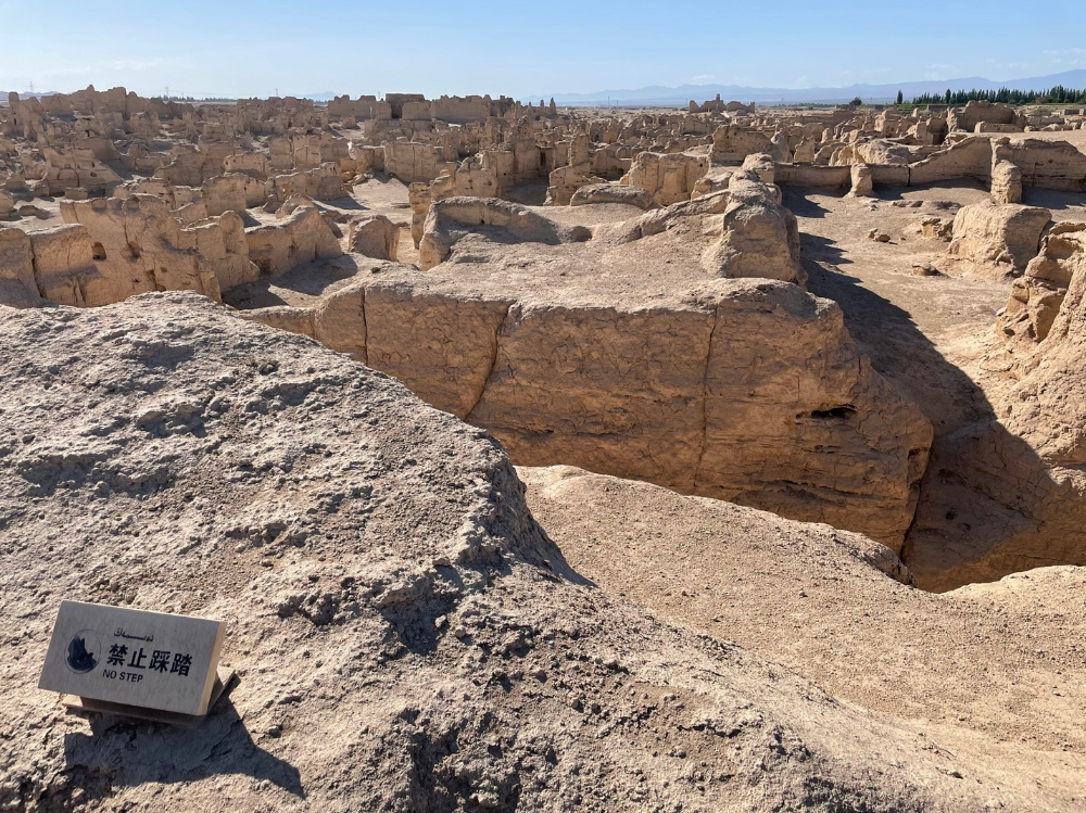
Commanding a plateau wedged in between two converging river ravines, the sprawling earthen ruins of the Ancient City of ‘Jiaohe’, once a bustling trading center and frontier outpost situated along the Silk Road, provides a vivid historical reminder of the flourishing interchange of commerce and cultures over the course of millennia within the Yarnaz Valley on the outskirts of Turpan City in northwest China’s Xinjiang Uygur Autonomous Region. (People’s Daily Online/Luke Witzaney)
As the contemporary name for the region suggests, Xinjiang has historically served as a “New Frontier,” a distant borderland lying west of the famous Jade Gate or Yumen Pass in a territory that had long been known as ‘Xiyu’, or the “Western Regions,” since the Han Dynasty (206 BCE – 220 CE). At the height of the Tang Dynasty (618 CE – 907 CE), Xuan Zang, a renowned monk who set out on a legendary pilgrimage to India to obtain sacred Buddhist scriptures, documented his nineteen-year travels in the “Great Tang Records on the Western Regions,” an influential text that would later go on to inspire the classic Chinese novel “Journey to the West” written during the Ming Dynasty (1368 CE – 1644 CE).
Even in the very earliest period of recorded Chinese history, the domain lying beyond the horizon of the setting sun had captivated the imagination, inspiring generations of mythmakers and pathfinders.
In ancient Chinese folklore, the “Queen Mother of the West” was the supreme goddess of the heavens and guardian of the Peaches of Immortality, offering up a promise of everlasting life to the few mortals who dared to make the treacherous thousand-li trek. She was said to dwell atop “Jade Mountain” in a remote and isolated terra incognita situated somewhere deep inside the far-off westernmost realms. Though the exact location of her paradisiacal abode will forever remain shrouded in mystery, it is a distinct possibility that the female deity resided somewhere in the Kunlun region in or near present-day Hotan Prefecture, southwestern Xinjiang, once a major source of the highly coveted jade stones that were quarried and transported to the great plains of China since remote antiquity.
Jumping forward into the 21st century, and the well-worn pathways traveled by caravans of merchants and traders riding on camel-back and donkey-carts have given way all at once to the hot-rolled steel tracks of iron horses, air routes for internal combustion engine-propelled aeroplanes and satellite-guided motorcades of electrically-powered automobiles.
Geographical access to Xinjiang has never been easier, with the region now at the pivot point of a modern-day dream aiming to revitalize a Silk Road connecting up Xinjiang with the rest of the Chinese mainland, while building a land bridge across the whole of the Eurasian land mass. The Belt and Road Initiative unveiled in 2013 promises to further expand regional integration while boosting two-way trade and investment across international boundaries, stimulating economic growth and promoting people-to-people ties beyond China’s borderlands and seaports. China’s northwestern gateway to the rest of the continent has never been quite as welcoming and not since the birthplace of ancient Chinese civilization on the winding bends of the Yellow River has the notion of “going west” taken on greater meaning – albeit this time encompassing the wider world and a broader vision of globalization, openness and inclusivity.