


The Kunlun Mountains, also known as Kunlunxu, the top sacred mountains in China, the birthplace of all mountains, Kunlunqiu or Yushan Mountains. It is a huge mountain system in central Asia and the main part of the mountain system in western China. It starts from the eastern part of the Pamirs Plateau in the west, spanning Xinjiang, Tibet and Qinghai of China. The total length is about 2,500 kilometers. The average altitude of the Kunlun Mountains is about 5,500-6,000 meters, with a width of 130-200 kilometers and a total area of more than 500,000 square kilometers, presenting a shape of narrow in the west while wide in the east.
The western margins of the Kunlun Mountains in China is extremely magnificent and majestic. There is a 7000 meters mountains group called “the three majestic peaks of the Kunlun Mountains”, which is composed of three snow-capped peaks, namely the Muztag-Ata Peak at an altitude of 7509 meters, the Kongur Tiube Peak at an altitude of 7530 meters, and the Kongur Peak, the highest peak of the Kunlun Mountains at an altitude of 7649 meters. The beautiful Karakul lake lying in the middle of them.
The Muztag-Ata Peak, lower than the other two peaks just mentioned, covers a large number of glaciers, so it has the laudatory title of “the father of glaciers”. The Kongur Tiube Peak looks like a wide hat, and its name coincidently means “white felt hat” in the Kirgiz language. The Kongur Peak is linked up by Karayaylak Glacier with the Kongur Tiube Peak 15 kilometers away. The Karayaylak Glacier extends for dozens of kilometers, and the thickness of the snow and ice can reach 100 meters.
The Kunlun Mountains is high in the west and low in the east, and divided into 3 sections in the west, middle and east according to the terrain. The Xinjiang-Tibet Highway, which passes from Setu La on the upper reaches of the Karakash River and Maza on the upper reaches of the Yarkant River in the western section of the Kunlun Mountains, is the watershed boundary between the western and central sections of the Kunlun Mountains. The main mountain passes in the western section of the Kunlun Mountains are Uzbel Pass, Mingtiegai Pass, Khunjerab Daban Pass and Kangxiwar Pass, which are the traffic arteries leading to Afghanistan and Pakistan. Blocked by mountains, the annual precipitation in the Karakash valley is only 25-30 mm, while the precipitation near the snow line is about 300 mm. The precipitation on the northern slope is greater than that on the southern slope, and the main peak forms the center of modern alpine glaciation, the 0 °C annual average temperature of isotherm roughly passes along the 4000 m contour line, and the annual average temperature of the highest mountain belt is -15 ~ -7.5 °C.
The middle section of the Kunlun Mountains sits in the Xinjiang-Tibet Highway and Nine Daban Mountains of the Qarqan River, which is on the 77 degrees to 86 degrees east longitude. The main vein of the Kunlun Mountains is slightly arched to the south. And the Keriya Pass and Karamiran Pass are the routeway linking China’s Xinjiang and Tibet.
The average altitude of the middle section of the Kunlun Mountains is 5000~5500 meters, and the snow line on the northern slope is 5100~5800 meters. The main rivers of this section are Karakash River, Yurungkax River, Keriya River, Niya River and Andir River. Except for the Karakash River and the Yurungkax River at the upper source of the Hotan River, which have a large volume of water and are favorable for irrigation, the other rivers are quickly submerged into the Taklimakan Desert runoff from the mountainous area.
The eastern section of the Kunlun Mountains is slightly fan-shaped to the east and divided into 3 branches. The northern branch is the Qimantag Mountains, the south of which is separated by the Ayakekumu Basin, and the eastward extension of it is the Tangsong Ural Mountains and the Burhanbuda Mountains. The middle branch is the Arge Mountains that topographically connects the Animaqing Mountains, the eastward extension is the Boka Rekhtag, Tangge Ural Mountains and the Buqing Mountains. The southern branch is the main mountain range that forms the Southern Qingnan Plateau.
The northern slope of the mountain is the desertified grassland where below the altitude of 3600 meters is a dry and denuded bedrock mountain with few plants but piles of scattered Ceratoides compacta, Reaumuria soongorica, Sympegma regelii on the ditch slope and rock debris. At a sea level of 3600 ~ 3800 meters, the vegetation features with high mountain grassland of stipapurpurea steppe. At a sea level of 3800 ~ 4500 meters of the mountain, the lower part of the grassland is covered by alpine meadow grassland with kobrecia parva while the upper part is mainly cushion-like vegetation. At a sea level of 4500 ~5000 meters, sparse vegetation that grow in high and cold area, and Frost Weathering Area show themselves. Above 5500 meters is the alpine snow and ice area.
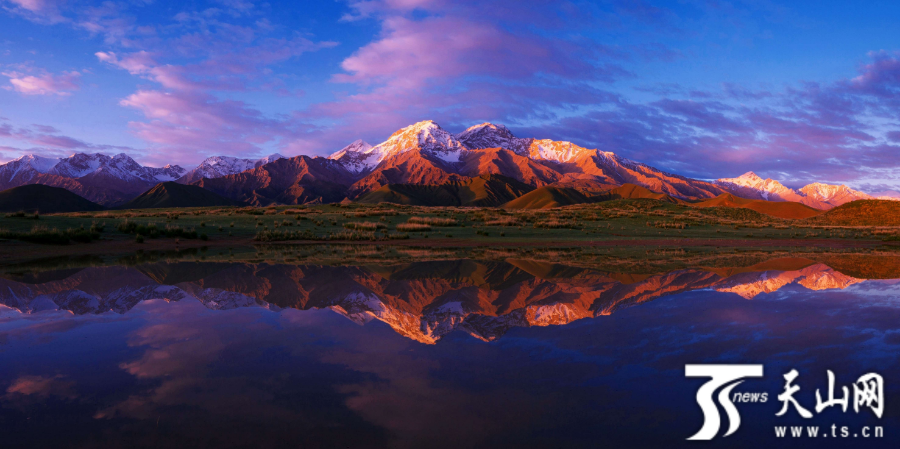
The Kunlun Mountain Range starts from the Pamirs Plateau in the west, with a total length of about 2,500 kilometers and an average altitude of 5,500-6,000 meters, narrowing in the west and widening in the east, covering a total area of more than 500,000 square kilometers. (Photo by Ma Xinye)

The peak is 7530 meters above the sea level, and because the snow accumulates on the top of the mountains all year round, it is like a hat worn by herdsmen, so local herdsmen call it “Kongur Tiube”, which means “white hat”. (Photo by Wang Shusheng)
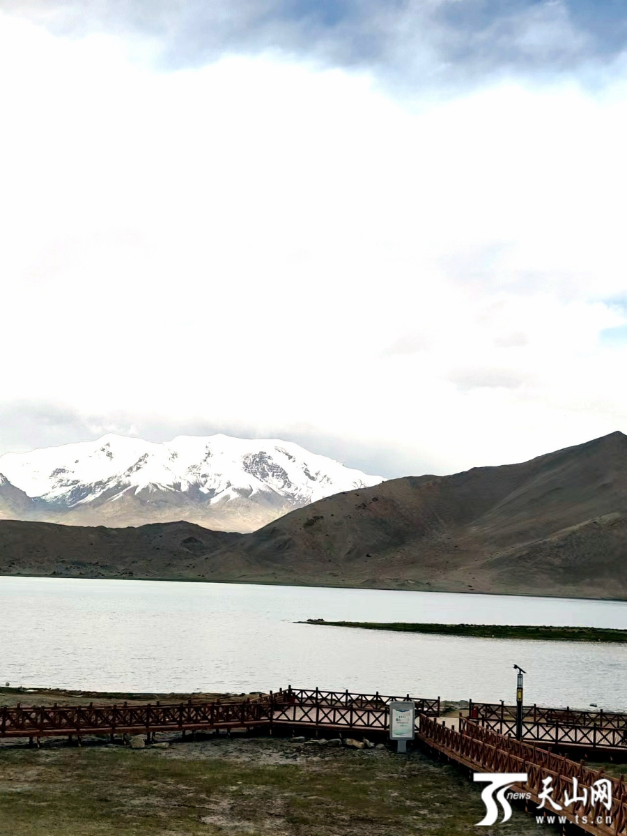
Photo shows the Karakul lake. (Photo by Ma Xinling)