Shiliuyun-Xinjiang Daily (Reporter Xie Huibian, Liu Yi) news: “Enormously devastating earthquake occurred in a mountainous and remote part of China’s western Xinjiang early Tuesday, luckily, houses at the county and township levels experienced minor damages. Based on current statistics, most of the houses that collapsed were in remote areas and were mainly built by residents. The new public housing recently built by the government did not collapse. The earthquake-resistant and comfortable housing project shows its own advantages,” said Jialin Nuerhamiti, the director and the deputy secretary of the Party Committee of Emergency Management Department of Xinjiang.
According to Jialin Nuerhamiti, Xinjiang has vigorously carried out the earthquake-resistant and comfortable housing project, especially in recent years, under the framework of the poverty alleviation and rural revitalization projects supported by provinces and municipalities involved in the pairing-up assistance to Xinjiang. As a result, houses in rural areas of Xinjiang have been reinforced.
Since 2004, Xinjiang has been the first in China to implement the earthquake-resistant and comfortable housing project in rural areas, with a focus on improving rural residential houses to be earthquake-resistant. From 2009 to 2010, with the support of the central government, Xinjiang carried out pilot projects for the renovation of dilapidated rural houses. In March 2011, the Ministry of Housing and Urban-Rural Development, together with relevant departments, included the Xinjiang urban and rural earthquake-resistant housing project in the scope of the central support for the renovation of dilapidated rural houses in accordance with the central requirements, and officially implemented the construction of rural housing project in Xinjiang. After nearly 20 years, Xinjiang has taken the lead in achieving full coverage of rural earthquake-resistant houses nationwide.
A 7.1-magnitude earthquake jolted Wushi County in Aksu Prefecture in northwest China's Xinjiang Uygur Autonomous Region at around 2 am Tuesday. The epicenter, with a depth of 22 km, was monitored at 41.26 degrees north latitude and 78.63 degrees east longitude, said the China Earthquake Networks Center (CENC). The earthquake caused strong tremors in the surrounding areas, such as Aksu Prefecture, Kizilsu Kirgiz Autonomous Prefecture, and Kashgar Prefecture.

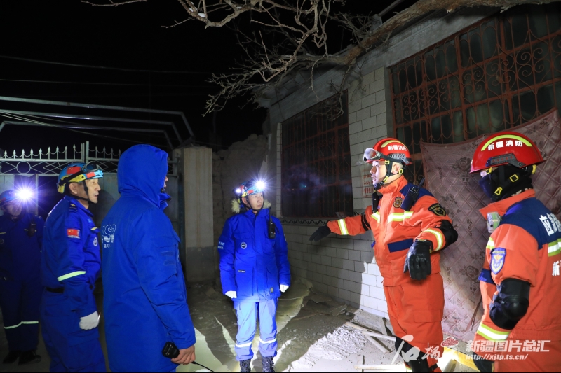
Photo shows members of the Xinjiang Blue Sky Rescue Team and firefighters check and clear dangerous situations in villagers homes. (Photo provided by Xinjiang Blue Sky Rescue Team)
“This 7.1 rating is very strong, but the death and injury situation is not severe,” said Zhang Yongjiu, the head of Xinjiang Earthquake Administration. According to Zhang Yongjiu, there are mainly two reasons for this. On one hand, the quake's epicenter was located in a mountainous area about 3,000 meters (9,800 feet) above sea level, and the area's sparse population contributed to the “very strong” quake's low death toll. The average elevation within a five-kilometer radius of the epicenter is about 3,048 meters, and the population is sparse. On the other hand, the depth of seismic sources is 22 kilometers, which is relatively deep.
As of 19:00 pm on January 23, 2024, the Xinjiang Earthquake Administration, together with CENC, had held four conferences consulting this earthquake. According to comprehensive analysis, this earthquake is a typical mainshock-aftershock sequence with abundant aftershocks. People in the earthquake stricken area should stay away from damaged houses and not return to damaged houses temporarily to avoid the danger caused by aftershocks, Zhang said.
Xinjiang is located at the forefront of the collision between the Indian Ocean Plate and the Eurasian Plate, resulting in the frequent occurrence of earthquakes with high intensity, and wide distribution, making Xinjiang the region with the highest level of seismic activity in mainland China.
Based on statistics, in this area, an earthquake of magnitude-five or above occurs five times about every year on average, an earthquake of magnitude-six or above occurs once, and an earthquake of magnitude-seven occurs once about every five to six years on average. There are multiple seismic zones distributed in Xinjiang, from north to south, there are the Altai seismic zone, the North Tianshan Mount seismic zone, the South Tianshan Mount seismic zone, the West Kunlun Mount seismic zone, and the Altun Mount seismic zone. This 7.1 magnitude earthquake occurred in Wushi County, Aksu Prefecture, which is located in the South Tianshan Mount seismic zone, and is one of the main strong earthquake zones in Xinjiang.
(A written permission shall be obtained for reprinting, excerpting, copying and mirroring of the contents published on this website. Unauthorized aforementioned act shall be deemed an infringement, of which the actor shall be held accountable under the law.)


